Mobile RCS and Imaging Radars |
|
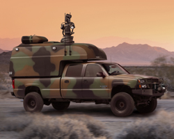
| A special capability offered by the Radar Signature Management Group enables target RCS and
imaging measurements to be made in the operational environment. The subject platform can in
these circumstances, for example, make representative operational manoeuvres or deploy
countermeasuressuch as chaff. The Company owns and operates three mobile, fully instrumented,
measurement radar systems, allowing signature data to be gathered from land, sea or airborne
locations. Comprehensive measurements are possible in all the radar threat bands from
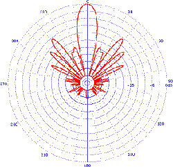
100 MHz to 100 GHz. The radars have been specifically designed and developed to provide state-of-the-art performance at trials locations worldwide. International acceptance of this capability has resulted in the radars having been used throughout the UK, Europe and in the USA, on a variety of different platforms. The performance offered by these advanced radars is exceptional, and they utilise both frequency and polarisation agility, on a pulse-by-pulse basis, in order to acquire high resolution measurement data simultaneously. In addition to their pulse by pulse agility, the radars also utilise a variety of wide-band intra-pulse modulation bandwidths enabling the achievement of ultra-high range discrimination. Target imaging (SAR or ISAR) has been achieved to better than 10 cm resolution. |
|
MIDAS - Mobile Instrumented Data Acquisition System MCR - Maritime Cliff-top Radar |
|
|
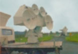
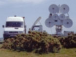
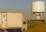
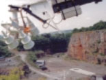
MIDAS and MCR are the land-mobile radar facilities which have been designed for quick deployment use in land-based radar trials. Targets can be tracked accurately in their normal operating environment using optical, thermal imaging and radar tracking techniques, to ensure consistent illumination of the subject platform during the radar data gathering exercise. The MIDAS can also conduct aircraft trials whilst ‘slaved’ to a stand-alone mono-pulse tracking system. The facilities can also be configured for use from other platforms, such as ships, where it can be used for measurements supporting Radar Ocean Imaging programmes. Another application using the MIDAS is to fit the associated RF assemblies onto a crane boom, thus achieving variable depression angles, support MTI and turntable (ISAR) programmes. Extended cable looms connect the RF and control infrastructure to the radar system. The MIDAS can also be configured to operate in a dynamic drive-by mode, collecting SAR data in support of target identification programmes. |
Technical Specifications |
|
| Operates from static or moving vehicle • Multi-mode • Multi-band |
• Continuous frequency band coverage • Fully coherent • Fully Polarimetric |
|
Frequency Bands Continuous frequency coverage from 10MHz to 110GHz is also available. Polarizations
|
Pedestals Antennas |
Modes Frequency-agile Polarization-agile Pulse-by-pulse data recording User definable transmit waveforms Simultaneous two-channel, co and/or cross-polar receiver |
 |
Data Gathering Modes These unique systems are fully supported by
experienced staff who manage the operation
of these systems. In addition to carrying out of In addition, Antenna Wireless Inc. certification
training programs are available for our
customers for independent operation of these
|
|
|